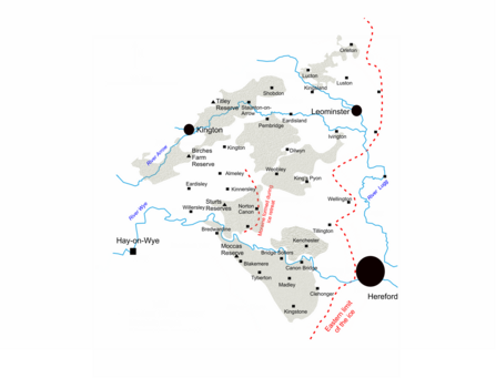
Let’s take a trip back in time to when great ice sheets covered the earth and woolly mammoths and rhinos co-existed with our ancestors. We are talking about the last Ice Age, around 20,000 years ago, when a huge ice sheet flowed down from the Welsh mountains and covered north western Herefordshire. The glacier edge follows the route of the A49 surprisingly closely, as you can see from the diagram in figure 1. The red lines show the extent of the glacier, the smaller one is a moraine caused by the glacial retreat. The shaded areas are the locations of the hummocky moraine and glacial deposits, these deposits stretch right from the Welsh border to Hereford itself.
How on earth did Ice Age ponds form?

The extent of the glaciers reach in Herefordshire, including modern day settlements
Figure 1: The extent of the glaciers reach in Herefordshire, including modern day settlements.
Although the ice disappeared many thousands of years ago it left behind clues across the county that help us to build a picture of where it was and how it carved out the landscape.
The ice lay over this part of Herefordshire for only a brief time (brief geologically, although we are still talking a few thousand years). When it retreated large lumps of ice and debris were deposited across the landscape. The deposited mounds of debris are known as moraines, in Herefordshire these have formed into random mounds across the county, known as hummocky moraine. We can identify these hummocky moraines because the material that is found in them differs from the rock found elsewhere in the county.
Ice Age Ponds
In our project area we have identified three different ways in which the glacier carved out ponds in Herefordshire.
Typical kettle-hole ponds
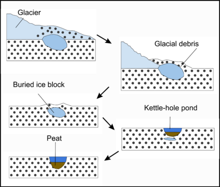
The first of these are also the most abundant. Along with mounds of sediment as the glacier retreated lumps of ice would have broken off its base and been left behind (think iceberg sized lumps rather than ice cubed sized lumps). The glacier would then have covered these lumps with sediment, burying them under mounds of sand, dirt and rocks.
Over time the ice would slowly have melted forming a cavity in the ground. The sediment at the top of the cavity drops to the bottom and over thousands of years breaks down to form peat. The peat is now at the base of a depression and this depression fills with water. And there you have an ice age pond. The cartoon in figure 2 shows this process happening step by step.
These ponds lie in amongst the hummocky moraine.

Figure 2: The formation of a kettle-hole pond
Letton lake
Some of you may have visited the Sturts nature reserve and noticed that there is a lack of hummocky moraine, despite the ponds being of ice age origin. These are our second type of ice age pond.
During the last Ice Age, the glacier retreated and advanced several times. During one of these periods a mound of moraine was deposited near to Norton Canon. This formed a dam and a large lake built up behind it. This is known as Letton lake.
On the lake there would have been a great many icebergs floating which wouldn’t have melted because of the continuing low temperatures. However as the water levels began to drop these icebergs would get stuck to the base of the lake and eventually would have melted. These melting icebergs formed the ponds scattered across the area where Letton lake once was. Many of these ponds are little more than shallow depressions in the ground and spend a large portion of the year dried out. Their ephemeral nature means that they are an important habitat for amphibians and many semi-aquatic plants as well. Check out this blog to find out more about the vegetation around Ice Age Ponds.

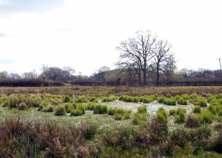
One of our ponds at Sturts North Nature reserve will lots of emergent vegetation, Carex acuta (c) Will Watson
Above: A Kettle-hole pond at the Sturts reserve. Notice how flat the surrounding area is, this would have been the base of Letton lake.
Meltwater channels
The final type of ice age pond that you can find in Herefordshire form a ‘necklace’ effect along what would have once been a meltwater channel to the south of the river Wye.
Meltwater channels flow underneath a glacier and they experience high levels of pressure from the weight of the glacier, which sometimes causes them to flow upstream!
As the meltwater channel flowed it would have formed pools and depressions, much like streams do today. When the glacier retreated and the meltwater stream no longer flowed the water was retained in these peat lined depressions, forming a ‘connect the dots’ for the meltwater channel. We can identify these ponds from the peat that the British Geological Survey has identified as existing at their base. During the Ice Age ponds project we have been out augering (taking core samples from the ground), and have found peat at a number of sites. To learn more about why the peat in the ponds is important why not check out our blog ‘What Ponds do for Us’

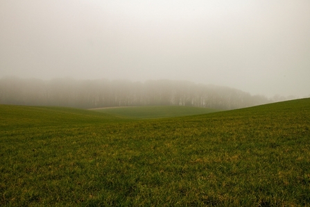
Hummocky moraine in the mist © Will Watson
Above: Hummocky moraine in the mist © Will Watson
To learn more about the geology of Ice Age ponds and the Ice Age landscape of Hereford you can listen to this wonderful talk given by Ian Fairchild of the Earth Heritage Trust who explains all of these processes and how we can identify them.
https://www.herefordshirewt.org/iceageponds/ice-age-ponds-history-geology

