River Naturalness surveys
Organisation:
Freshwater Biological Association https://priorityhabitats.org/
Action:
To get involved with this project and contribute data, you will need to complete a naturalness survey on your chosen site, be it a lake, river, or stream
The current knowledge of our freshwater habitat network mostly relates to larger rivers and lakes because this is where the focus of water management activities has historically been. We know much less about our smaller rivers, streams, and small lakes, but we do know there are hidden gems in the landscape – natural habitats full of rare and crucial native wildlife. While some areas are more ‘natural’ than others, the FBA and Natural England want to know about all of our freshwater habitats whatever their state of naturalness so this can inform restoration priorities
By submitting simple and easy to collect naturalness data, citizen scientists will form a network of individuals across England who will work to discover new priority habitats, prioritise conservation action, and direct restoration work for damaged freshwater habitats. Local individuals are in the perfect position to collect data for these smaller freshwaters that surround their homes, and to help to better understand our country’s priority habitats.
Location:
England wide. Site selection is very flexible, but please bear in mind that our knowledge gaps relate to smaller waterbodies that aren’t currently assessed by statutory monitoring methods.
Level of commitment:
No commitment required, naturalness surveys can be completed as and when
Training required:
You don’t have to be an expert – the assessment is designed to be used by anyone. The FBA have created guidance documents and annexes that will help you to do this, as well as printable versions of the forms that you will eventually fill in online. The resources provide tips on how to fill out the forms, and how best to capture data about your site. Documents are available in PDF format.
Kit needed / provided:
FBA use an online data portal to collect, organise, and map naturalness data
Outcome:
Your input can help target the best places for restoring rivers, streams and lakes so that they can function more naturally and provide the best possible habitats for our wildlife.
Naturalness data will be used by Natural England and the NCEA to update the official priority river/stream and lake habitat maps. Information on sites not currently in a state to be added to the priority habitat map will be used to inform restoration priorities. If a site is restored to a sufficient level of naturalness it can then be added to the relevant priority habitat map.

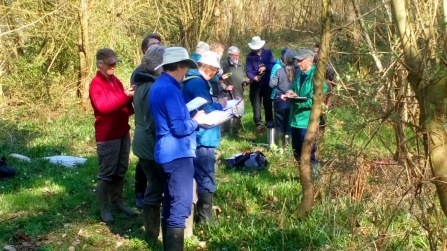
Volunteers learning survey techniques in the field (Andrew Nixon)
