Visit the Ice Age Landscape of North West Herefordshire
Herefordshire’s Ice Age Landscape
The area of Herefordshire that lies to the North West of Hereford was covered by a large ice sheet that travelled down from Wales during the last Ice Age, roughly 10,000 years ago. This has sculpted the landscape we see today.
There are a number of areas around the county where you can visit Ice Age Ponds and other landscape features. The following maps provide some sites of key interest to visit
A key to the maps:
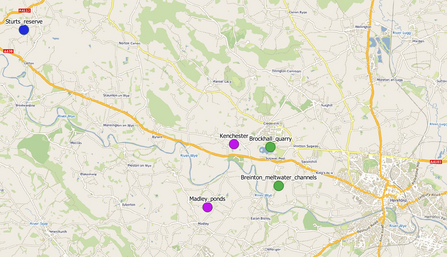
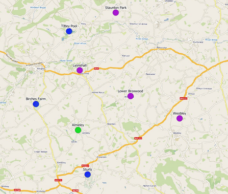
Blue dots: These show where there is a Herefordshire Wildlife Trust reserve with Ice Age Ponds. To find out more about visiting these reserves, including details of parking you can visit our reserves page here.
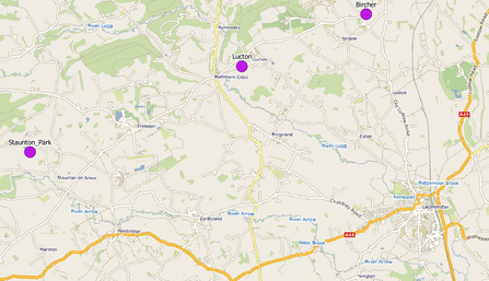
Purple dots: These show Ice Age Ponds that can be accessed via a public footpath. These ponds will be shown on 1:25,000 OS maps and the name indicates a nearby village or farm for reference.
Green dots: These indicate Ice Age features that may not be ponds. More details of these can be found on the following pages.

Ice Age Landscape Map (1)
Landscape Features
Brockhall Quarry
This area represents a moraine where the glacial deposits are unusually thick, being deposited when the ice margin was at this location, the mounds created by these deposits are known as moraine. The deposits include till, layered lake deposits and thick sands and gravels from meltwater streams and reveal a complex history of ice advance and retreat. Stones lying on the surface today show characteristic shapes where they have been transported under ice.
Breinton Common
At Breinton common you can walk along the top of meltwater channels. As you follow the footpath via the ‘upper wood’ you will see two deep valleys carved out of the landscape. These were formed by rivers of meltwater flowing under the glacier. Like a river carving out gorges in the landscape today these meltwater rivers would have done the same to the glacier. With one key difference, the immense pressure from the glacial ice would have forced these rivers to flow uphill rather than downhill. So as you stand on the top of the hill the water would have been flowing towards you!
Almeley dingle
The dingle at Almeley is one of a number of dingles in this area and is called the Batch. A nice walk from Almeley will take you up the Batch to Almeley Wooton where you can then circle back to the start. You will pass a couple of old hill forts on your way. As you make your way up through the Batch pay close attention to the stream bed. At points (notably the small waterfall) you will see the bedrock exposed. This bedrock dates back to the Ice Ages.

Ice Age Landscape Map (2)

Ice Age Landscape Map (3)
Why not take a walk to an Ice Age Pond?
Madley
The ponds near Madley are found a short way north of the village. There are a number of Ice Age Ponds on the footpath between The Bage Farm and Churchfield. You can also see example of where recent work has altered the shape of some of these ponds.
Kenchester
You can view the ponds at Kenchester just off the Three Rivers Ride, south of Court Farm.
Weobley
There are a number of ponds in the Weobley area and quite few can be seen from footpaths between Weobley and the Haven
Staunton Park
Why not walk around Staunton Park and see how many ponds you can spot. How many of these look like they may have been modified?
